Temporary Conditions
Because of a bridge closure that occurred in early 2024, we will be using a temporary course again in 2026. Based on feedback after the 2024 race, we will be using the 2024 out-and-back course. The new course has been measured and has USATF certification number NC24007DF. You can view the certification map. The course will keep its traditional start / finish / Headquarters area.
Course Maps
Start/Finish
The start/finish line is located at the Camp Lapihio Headquarters.
Laps and Spurs
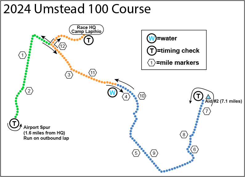
The course is a 12.5 mile lap in Umstead Park that you repeat eight times to reach 100 miles.
All junctions are marked with signs to help guide you.
To allow the field to spread out, the race starts on the single-lane gravel road in front of the race headquarters. The start is the only time that you will run on this road. Beginning with the return to HQ on lap 1, the remainder of the eight laps will use the Hills/Oaks/Lot A/Lot C parking access road and pedestrian path to reach the Start / Finish line timing tent.
For 2025, the 12.5 mile lap will consist of two out-and-back segments. The route is the same that we used in 2024 and may be described as follows:
0.0M Exit HQ from S/F line
0.7M Turn right onto Reedy Creek B/B
1.6M Turn around at Airport Spur timing mat
Stay on Reedy Creek B/B to near Trenton Road gate
5.7M Turn left on S. Turkey Creek B/B
7.15M Turn around at Aid Station 2 timing mat
8.55M Right-turn merge onto Reedy Creek B/B
11.8M Turn right toward HQ
12.5M S/F line
In addition to the fully-stocked aid stations at Headquarters and the second turnaround, the Reedy Creek & Graylyn Water Point will be in operation. Runners will pass this Water Point at approximately 3.8 miles and 10.5 miles meaning that you will never be farther than 3.8 miles from hydration, calories, and a bathroom.
Topography
The course is rolling hills with a total of about 7,250 feet of climb over the 100 miles (about 900 feet per lap). The entire course is runnable for front-runners with nicely spaced hills. Getting lost, even for a short time, will be difficult (but not impossible). The course is well marked with Umstead 100 Logo direction signs. At night the course is marked with glow sticks.
For the temporary course, the traditional North Turkey Creek section of the trail is being omitted, meaning that you will not have the opportunity to experience the steepest trails in the park.
Surface
The majority of the course is along well-maintained running, biking, and horse trails. There is a short portion of each lap that is on a rougher, gravel road that culminates in a pedestrian trail with steps to/from the timing tent at the lap start/finish. There is no single-track trail on the course. All creek crossings are on permanent bridges.
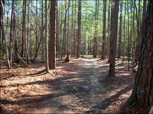
The multi-use trail, which comprises 93% of the course, varies in width between 8 and 15 feet and the footing is excellent. There are some sections with ruts and loose gravel. Most of the multi-use trail is very well compacted.
The roughest part of the course is on the vehicle access road portion of the course leading into and out of the Camp Lapihio Race Headquarters. The road into HQ is approximately 0.4 miles each way. Along this section , there is larger crushed gravel that is typical for automotive traffic as well as a few roots. As you return to the Start/Finish area, you will pass through the Hills and Oaks cabin areas, Lot C, and Lot A with canopies on both sides of the trail. After passing Lot A, there is a short climb with several steps to reach the timing tent.
For the temporary course, there is one wood decking bridge that will be crossed twice per lap. This bridge was recently repaired and is in excellent condition.
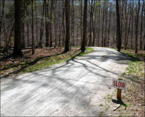
The picture below is a typical part of the multi-use trail. While you might be running fast enough to need that SLOW sign, it's really for the mountain bikers who might be coming down the hill at warp speed. Stay alert!
In the picture below you can see a portion of the 0.4 mile access road in Camp Lapihio. Some of that trail has less gravel than other parts. A heavy rain can turn these parts a bit muddy, so be prepared.
Here are more pictures of the course, courtesy of Ben Dillon.
Footwear
Here at Umstead 100 World Headquarters, we have some differing opinions about the best footwear for this course. Some recommend a light trail shoe. Others believe that given 93% of the course is on very well compacted earth, that a well cushioned, regular running shoe is better. Some also recommend gaiters to keep the grit out of your shoes while others don't feel they are necessary.
In the end, the decision on shoes and gaiters comes down to what will make you happiest over the course of a day. When you are making your footwear choice, we will emphasize that this is not a technical course and there are no single-track sections. Unless it is heavily raining, most of the multi-use trail is well compacted.
Traffic on the Course
On the majority of the course there is no motor vehicular traffic except the State Park vehicles and official race vehicles. There is 0.4 mile of the course with light park traffic that consists of race/crew vehicles.
A bigger issue is that there will be bicycle traffic on the multi-use trail while the park is open to the public. As with every large population, there will be a range of care and consideration exhibited by the cyclists. In addition to pedestrians, there may be a few horses on the trail during the day.